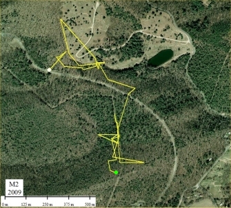
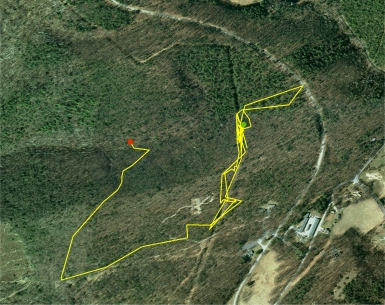
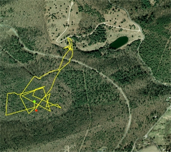
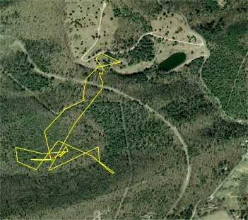
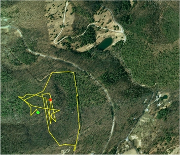
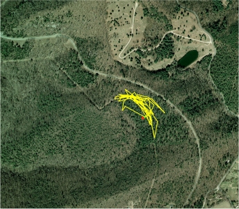
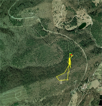
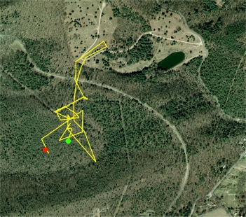
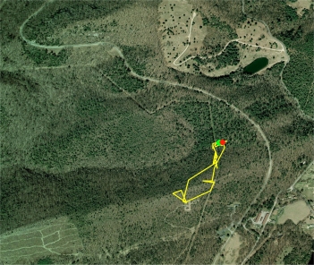
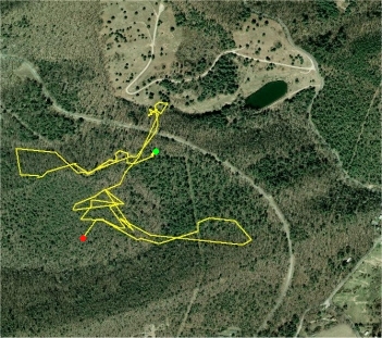
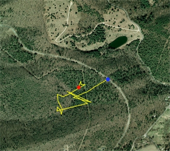
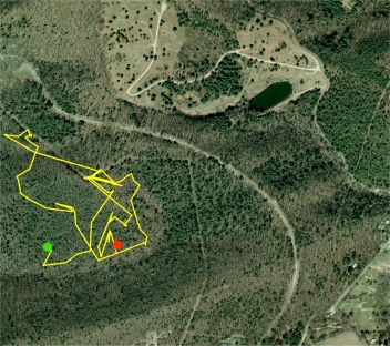
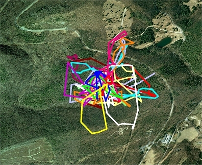
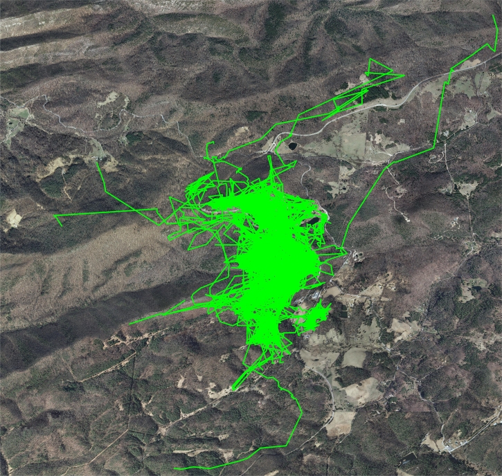
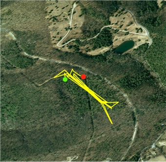
Turtle M1 is a very old, large (560 gr) female that was found crossing the road on 7/5/08 and has been tracked every season since.  M1 is an active long distance traveler who's primary activity area is approximately 19 acres, located on a steep south-facing slope with an oak-hickory overstory.  She rarely uses a resting form or spends much time basking in direct sun, and travels routes in long straight stretches.
Turtle M2, Dead, a middle aged, medium size (410gr  14.1cm CL)  male was found 9/29/08 while crossing the road, and was tracked 0.3 miles in 2008 and 2.0 miles in the 2009 season  before being run over by a vehicle while crossing the road, likely headed for his primary activity area and winter hibernation area.   Turtles M4 and M11 were found mating with M2 and tagged.  M2 was killed while returning from M11's activity area. 

Turtle M2 was killed when he was run over intentionally by National Park Service employee, Charles N Painter, a  local redneck and sociopath, on his early morning commute to work.  As a result, all research turtles are now monitored while close to roads and crossings recorded, and some turtles assisted with road crossings.  The value of the future data is more valuable than a single road mortality statistic when the death can be avoided.


Turtle M3(Male) was found on 4/24/09 only one day before M1(F) emerged from hibernation, and only about 6 feet from M1's hibernation location.

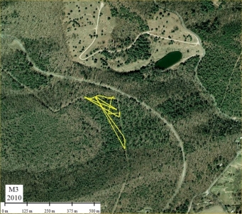
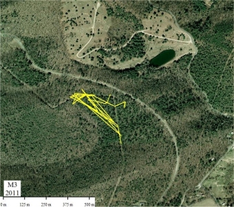
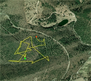
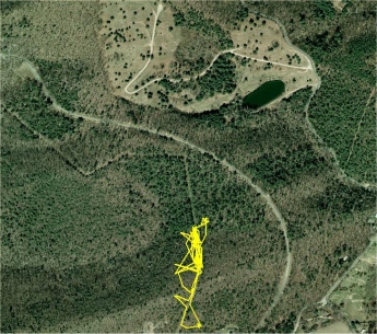
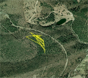
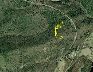
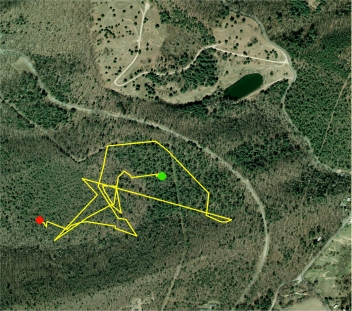
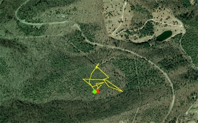
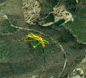
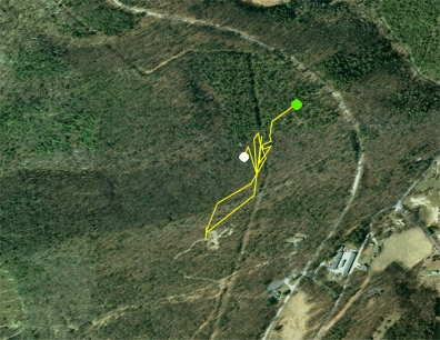
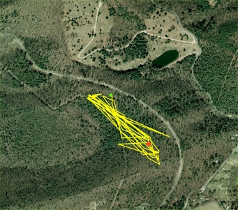
M3 is a 485 gram male whose primary activity area is comparatively small  (3.8 acres) and partly within the powerline Right-of-way (ROW), and has chosen a number of hibernation spots at the ROW edge and in the woods over the years.  M3 enters into hibernation on nearly the same day each fall.
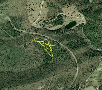
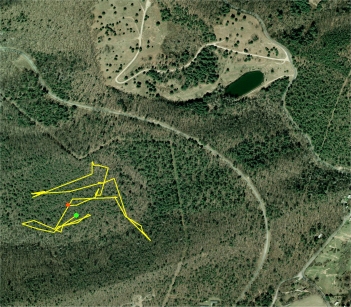
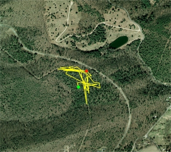
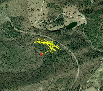
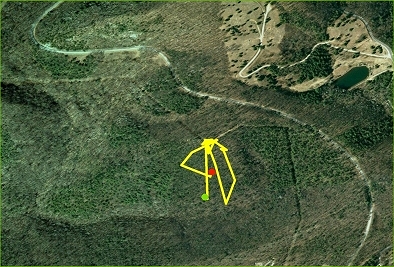
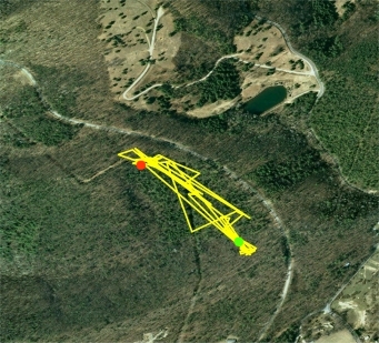
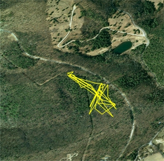
Turtle M3 poses an interesting problem when interpreting tracking data:  his primary activity area includes a dog-leg corner in the power line ROW, and although he is occassionally found in the woods inside the dog-leg, he is more often found in the ROW itself, so he might be traveling the ROW more than the route map indicates.  GPS miles tracked:

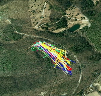
1.5 miles in 2009, 43 points
0.9 miles in 2010, 26 points
1.9 mles in  2011, 38 points
1.1 miles in 2012, 26 points
2.0 miles in 2013, 41 points
1.4 miles in 2014, 34 points
2.4 miles in 2015, 50 points
2.0 miles in 2016, 59 points
2.9 miles in 2017, 60 points
1.9 miles in 2018, 41 points
1.6 miles in 2019, 37 points
2.2 miles in 2020, 44 points
4.5 miles in 2021, 71 points
3.4 miles in 2022, 57 points
2.2 miles in 2023, 40 points

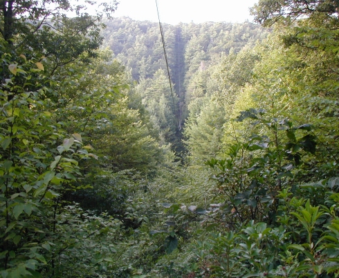
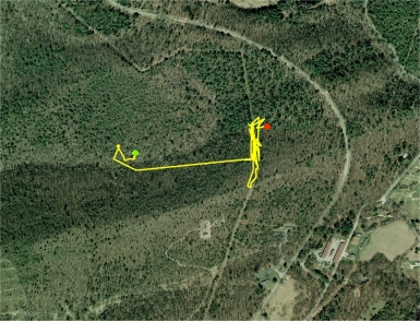
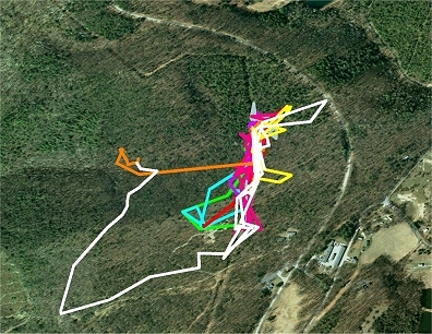
M3 has never been known to cross the road.  He seems particularly adept at locating other males for meetings, and females for mating.  His activity area includes some very steep and rough terrain with dense vegetation, and consequently is tracked less intensively than other resident turtles.  He likely mates and meets at least 3 times greater   than the number observed and recorded.

GPS distance tracked:

1.0 miles in 2009, 40 points
1.4 miles in 2010, 58 points
1.5 mles in  2011, 52 points
1.4 miles in 2012, 63 points
2.3 miles in 2013, 83 points
2.6 miles in 2014, 69 points
1.3 miles in 2015, 51 points
1.3 miles in 2016, 61 points
1.6 miles in 2017, 43 points
1.1 miles in 2018, 37 points
0.9 miles in 2019, 26 points
0.9 miles in 2020, 28 points (4 mo)

The powerline ROW was first cut in 1956 and has been mechanically trimmed only a few times since.  M4 is older than the 55 years the ROW has existed.  The power line changed ownership in the fall of 2010 and will no longer be maintained.  North facing ROW slopes (like M4's) are dominated by a heavy cover of ferns.   M4 spent most of her time traveling  among the ferns on the north facing slope, so the secession of maintenance may not have much, if any effect on her daily travels, at least in the short-run.


Turtle M5(Male), a 345 gram male, was found on 6/11/2009 while crossing the road, was lost for most of the summer, and re-found before seeking out a hibernation site.  M5 seemed unpredictable in his movements.  Although he did not originally appear to be a transient, an established primary activity area was not determined.

M5 was lost for most of the 2011 season, and was re-found just prior to hibernation.  After emergence he did not return to the location of the main population.  He was lost again prior to hibernation in 2012.


Turtles have inhabited the earth for over 200 million years, and Box turtles for 20 million years.  During the ice age, there were enormous box turtles more than 10 inches long, but Box turtle numbers are now decreasing throughout their range.  Box turtles have been studied since the 1930's but there are still a large number of questions researchers only speculate about.

Population Survival The lifespan for Box turtles is often 60 to 100 years or longer, and once they become sexually mature they can reproduce for well over 40 years. This is important because the mortality of their eggs, hatchlings and juveniles is very high, with an average annual survival rate near zero. This long-lived reproductive strategy makes Box turtle populations especially vulnerable to any disturbances that increase the rate of mortality in adults.

Mortality rates of adults in a normal Box turtle population as low as 2% annually, may be enough to eventually lead to the extinction of a local population, and in a small population, very small losses; i.e. the removal of even one or two adult turtles, can result in the gradual, imperceptible extinction of the population.

Due to the  longevity of the remaining individuals masking the critical instability of a population, it can take decades to recognize that the remaining geriatric population has long passed the threshold to extinction.  Low recruitment rates of juveniles replacing their missing adult parents makes population rebounds impossible.

When adult Box turtles are killed before being replaced by juveniles surviving to adulthood, the population declines inevitably toward extinction.  The Bottom Line


Study Area Description:    The core of this study area is approximately 650 acres of combined federal, state and private land located in the Appalachian Mountains of southwest Virginia in the Blue Ridge Bioregion between the Shenandoah Valley to the West and the Piedmont to the East.  The area has distinct winter-summer climatic seasons with occasional devastating ice storms and heavy winter snow pack.   These mountains are part of the Chesapeake Bay watershed.  There are no perennial, and few intermittent streams, creeks or seeps within the study area.

Site elevations range from 2900 to 3480 feet, with steep slopes and an overstory of oak-hickory-poplar-maple-pine.  The soils are harsh and overly well drained of the Marbleyard type.   The site is primarily forested with small natural meadows (treefalls), small clearcuts, powerline rights-of-way, and a USFS hiking trail.  There is one seasonally heavily traveled paved road that bisects the site, as well as much less traveled dirt and gravel roads.  The private land contains some residential development and the government land contains residences, maintenance shops, utilities, etc.

On the federal lands, wildlife is protected by federal law, and some wildlife is protected by numerous state laws.  In reality, little wildlife or natural resource protection actually occurs unless the opportunity for large restoration dollars exists.  Where the roadway speed limit is 45 mph, very little actual traffic enforcement takes place and most traffic travels much faster, especially on weekends and holidays and by local residents, resulting in dramatically increased road hazards to wildlife.  Speed traps elsewhere, air-conditioned law enforcement patrol vehicles, and frustrated law enforcement employees offer no (zero) wildlife protection! 


Road Crossing Behavior     Turtles in this population have a behavior (or procedure), for road crossing that is distinct from travel within their primary activity areas, ROW's or trail crossings, and is almost always followed.  Preparation for road crossing is characterized by a beeline track toward the road and an abrupt halt at the treeline or occasionally the mow line.  The turtle then waits at this location for 1 to 3 days.  Occasionally during that wait, she will move a short distance parallel to the road/treeline and if the wait is greater than a few days, she may make a move into the woods and loop back to the original roadside location,

The road crossing nearly always takes place in the early morning between daybreak and about 8:30 a.m. (at this study site), and after crossing , the turtle continues in the original direction sometimes with great haste.  It is not unusual for a turtle to appear to "rest" in the exact same location for several days before making a big move, but road crossing behavior is so predictable, that I can now be on-site to observe nearly every road crossing of known turtles and provide the necessary assistance to preserve future turtle data and equipment (lost when a turtle is run over).

The two exceptions to the above behavior are (1) crossings immediately following afternoon thunderstorms on hot steamy summer days, and (2) female crossings at night enroute to or from nesting areas.  The latter has only occassionally been observed in this population, but at least one research paper claims that this occurs commonly.  A couple female study turtles observed crossing during the night seem to use this behavior regularly.....while most others never do.
Road Crossing Mortality   Experiments with turtle sized and shaped models on a straight, level 45mph section of the paved roadway produced the following results:  When a turtle model is placed in either tire track in either road lane (any time of day), 3 out of every 4 cars or 4 wheeled pickups ran squarely over the turtle.  Three wheeled motorcycles were no better, and have a third track in the center of each lane and usually have very fat rear tires. Three wheeled motorcycles rarely swerve to avoid obstacles or even to give way to bicyclists or pedestrians. Two wheeled motorcycles nearly always swerve to avoid obstacles.

For busses, RV's, trucks and cars pulling trailers, a turtle in either tire track is doomed, as the mortality rate jumps to nearly 100%.  These vehicles almost NEVER swerve to avoid an obstacle whether rock, branch, snake or turtle or even to give space to a pedestrian beside the roadway, and many of these vehicles have wide, and sometimes multiple sets of wide tires covering most of the width of their lane of travel.  These described actions occur at nearly ANY SPEED making these vehicles the worst offenders of wildlife mortality travelling the highways.

If a turtle reaches the center line, the survival rate is better, but only for the time it is actually on the yellow line.  There is still one more lane to cross, so if there is traffic, the same probability of death occurs once again.

Some drivers interviewed, especially locals, actually swerve to run over Box turtles intentionally "to hear the pop they make" when hit. Here is a video on a roadkill experiment and here is the YOUTUBE link.
This aerial photo shows over 14,000 GPS locations and routes which were recorded during the summer seasons of the 16  year period of 2008 through 2023:     Annual tracked routes for all turtles are HERE.
Home Range and Activity Areas:  Home range is one of the core concepts of modern spatial ecology, and has been used since Burt (1943) defined it as “that area traversed by the individual in its normal activities of food gathering, mating and caring for young.”     Home range indicates the manner in which an animal uses it's habitat.  Thus the distribution of resources necessary for survival and reproduction determines the amount of time and energy spent in any particular part of the home range.  And Burt went further: "Occasional sallies outside the area, perhaps exploratory in nature, should not be considered as part of the home range”.  Although  Dodd (2001) states that "feeding, exploratory,  and nesting forays may extend the home range of T. carolina ".

Defining and discussing Home range can be confusing, and many research papers on Box turtle home range never attempt to define the term, or how the term is used in their own research.  Home range size and location may change over time, and multi-year location studies are absolutely necessary to understand the importance of a Box turtle's season movements.

The simplest way to define the boundaries of a home range is to draw the smallest possible convex polygon around the location data. But this method (MCP) is subject to sample size and is greatly affected by outliers often grossly  over-estimating the size of home ranges.

Associated with the concept of a home range is utilization distribution;  a model that describes the relative amount of time that an animal spends in any place within its home rangeSite fidelity is another concept used to describe when an individual's movement within an area is non-random.

Primary Activity Area is the term I prefer to describe Eastern Box turtle travel and their land use in this study.  It infers that  there can be secondary activity areas, and multi-season location sampling proves it's importance over the term "home range".

For turtles such as M3 (male) and M8 (male), their primary activity area may indeed also be their home range.  In contrast, turtle M9 (f) and M1 (f) have locations (primary activity areas)  to which they return after temporary travels away.


M1 All Years A 19 acre primary activity area verses 77+ acre home range as defined using location data alone.  M1 travels long distances to different areas annually, including occasionally crossing the road into the meadow, but returns to the south facing slope before hibernation.

The all years photo above is approximately 624 acres, 252 hectares, or 1.0 sq mile in area, and is the result of 24.5 GPS miles of travel
Powerline right-of-way shown on the aerial photos, photographed mid-summer looking south.  The ridgetop/ROW on the horizon is well within the boundary of the study area.
Hibernation
2013 Summer
2013 Hibernation
2014 Summer
2014 Hibernation
2015 Summer
2015 Hibernation
2016 Summer
2016 Hibernation
2017 Summer
2017 Hibernation
2018 Summer
2018 Hibernation
2019 Summer
2019 Hibernation
2020 Summer
2020 Hibernation
2021 Summer
2021 Hibernation
2022 Summer
2023 Summer
Meeting and Mating
Turtle Catalog
M17 Superturtle
Land Use History
Odds and Ends
The Bottom Line
Thread Trailing
Processing
Observations

ALL PAGE LINKS HERE
Page Loads Slowly
Be Patient
M2 hibernated high on a partially sheltered north facing slope in 2008 at a depth of 23 inches (the deapest ever recorded in this population).  The burrow was preserved with a 4 inch ABS pipe and continues to be used to record winter soil temperatures at that site.  GPS distance tracked (partial seasons);

0.3 miles in 2008, 11 points
2.0 miles in 2009, 39 points
Eastern Box Turtle
                Terrapene carolina carolina
High Elevation Study
A Relict Population Doomed To Extinction?
M1 2012  1.9 miles
M3 2012
M4 2012
M5 2012
2008-2024
"One in twenty-five people (4%) is a sociopath lacking empathy for other people or animals"

"It takes a mighty brave man to run over turtlesThe Great Santini
Back to Top of Page


Mapping and Data Collection Page
Philosophy and Methodology
Transmitters
Radios and Antenna


M4 2013
M3 2013
 
 
M1 2014  1.4 miles
M3 2014
M4 2014
In 2014 most of turtle M4's summer season was normal, but on August 8th, she started a very long trek initially traveling east to the wood's edge close to the roadway, where she spent 2 days, then turned west and traveled back to and across her primary activity area of the ROW and by September 7th was found soaking in a small spring in the hollow (drainage) to the south.  Later she crossed over the ridgetop and down into a large drainage, where she found a tiny pool to soak for about 8 days before moving uphill and hibernating.

She never made it all the way back to her normal hibernation area by the end of the 2014 season, but returned to her normal primary activity area in 2015 and hibernated near where she hibernated 2009 to 2013, and since.
Transient Identification
The photo represents approximately 4300 acres.

The vast majority of the traveled routes shown are of resident members of this local population.  The stringers that are heading away from the resident population (and continue out of range) are transient turtles;  many may never return, some may return in the future, but hopefully all deposited genes during the short time they were here, strengthening the gene pool.

Study Area Descriptive Maps are Located Here

A page explaining how to interpret Box turtle route maps is located here.

Annual Individual Box Turtle Travel Routes
 
Turtle M1
Turtle M2
Turtle M3
Turtle M4
Turtle M5
Green Dot = Emergence,  Red Dot = Hibernation, Blue Dot = NEW FIND, White Dot = Dead
Everything on this web site is copyrighted by James Basinger 2015
M4 2015
M1 2015  2.2 miles
M3 2015
 
In September 2015, M5 was re-found while crossing a road, by a local resident. Here is a page showing the great distance traveled in the 3 years he was lost.
Each aerial photo to the left is 318.2 acres or 129.2 hectares in size (or about 3935 x 3525 feet), 1/2 sq mile.
M4 2016
M3 2016
M1 2016  2.0 miles
Charts and Graphs

M1 2017  2.1 miles
M3 2017
M4 2017
 
M1 2018  1.7 miles
M3 2018
M4 2018
In 2018, M4 was found looking ill and was taken to the Wildlife Center of Virginia for treatment.  She was released just before hibernation, and after a slow start at emergence, traveled only a little less than normal during the 2019 season.
Photos of each turtle in this study are located here.
M1 2013  2.4 miles
Click here to go to the original entry page, which now has convienent links to ALL pages on this web site.
M3 2019
Fourteen years tracking turtle M3 (as of 2022), and he deviated little from his very tight activity area until the 2021 season, when he traveled far outside of this normal travel area to the Tank Road Meeting Area and the adjacent slopes many times.   The 'all years' photo shows 26.3 GPS GPS miles of tracked travel

M3 can be counted on to find females, some new, nearly every year, very often traveling from long distances, and often in the woods away from his primary seasonal travel routes within the power line ROW.

M3 selects different hibernation sites nearly every season.
M4 2019
DOCUMENT LINKS
M1 2010  2.0 miles
M1 2011  1.9 miles
M1 2008  0.9 miles
M1 2009  1.8 miles
M1 2019  1.3 miles
Page 1
 
M4 was found dead on 9/4/20 in the woods, the result of injuries from a small mammal attack.

M4 was tracked 17.3 GPS miles over 12 seasons.
Name

Subject


Message


Email Contact
This Page Continues
With Turtles M6 Through M13 Here
With Turtles M14 Through M23 Here
With Turtles M24 Through M31 Here
With Turtles M32 Through M43 Here
With Turtles M44 Through M54 Here
With Turtles M55 Through M74 Here


M4 All Years 2009 to 2020
M1 2020  0.9 miles
Green Dot = Emergence,  Red Dot = Hibernation, Blue Dot = NEW FIND, White Dot = Dead
M3 2020
M4 2020
GPS distance tracked;

0.9 miles in 2008 (3 mo), 25 points
1.8 miles in 2009, 43 points
2.0 miles in 2010, 81 points
1.9 miles in 2011, 41 points
1.9 miles in 2012, 46 points
2.3 miles in 2013, 87 points
1.4 miles in 2014, 44 points
2.2 miles in 2015, 51 points
2.0 miles in 2016, 41 points
2.1 miles in 2017, 41 points
1.7 miles in 2018, 38 points
1.3 miles in 2019, 19 points
0.9 miles in 2020, 22 points
0.9 miles in 2021, 26 points
0.3 miles in 2022, 17 points
0.8 miles in 2023, 12 points

Actual annual travel distance is much greater.

Many turtles were subsequently found (and tagged) mating with or in close proximity to M1 including  M3, M8, M9, M12,  M16 and others.  The Turtle Finding Chart Here explains.   M1 has a very smooth carapace.   Turtle M1 and other Turtle catalog photos are found here.

M1 nests annually, averaging 4 eggs per clutch.  No eggs have survived in the observed years: all being destroyed by racoons within a day of nesting.  She nests at different sites each year and occassionally crosses the paved road to nest in the meadow, and crosses again as she returns to her primary activity area.


A page describing M1's Study Area Features is available HERE
Turtle M4, Dead, (686 grams) was a very old female and the second largest turtle in this population.  She was found 6/3/09 mating with M2 (now dead) in one of the few small areas now recognized as "Meeting Areas".  M4 spent nearly all of her summer months within a power line Right-of-way (ROW), leaving occassionally after rains to search for mushrooms, slugs and snails in the adjoining woods, and to hibernate in a stand of Pines nearby nearly every fall.
ADDITIONAL PAGE LINKS HERE
Collecting and Using Temperature Data
Home Range vs Activity Area
Measuring Plastron Temps
All Years as of 2021
The Bottom Line Model
Antennas, Radios, other Equipment
Tracking Tricks and Tips
Using Labels and Message Vials
Mapping and Data Collection Page
Observations
     Mushrooms
     Water use
     Worn Carapace
     Road, Trail, and Path use
__ Land Snails
__Transients and Residents
__Aggression, Territoriality, and Home Range Patrol
__Randomness in Turtle Movement, Meeting and Mating
__Carapace and Body Temperature
__Edge Utilization
Mapping
Thread Trailing
Study Area Description
GPS logging
Understanding Box Turtle Route Maps
Transient ID
Research Opportunities
Philosophy and Methodology
Radios and RF Transistors
Transmitters
Box Turtle Fitness Index
DOCUMENT LINKS
Turtle Tracking Precision
M3 2021
M1 2021  0.9 miles
M3 2022
Each of the above photos is approximately 310 acres
M1 2022  0.3 miles
M3 All Years 2009 to 2023
M1 2008-2023
M1 2023  0.8 miles
M3 2023