"GPS distance" or "GPS miles" is not actual travel distance, but instead, the point-to-point distance between GPS waypoints as plotted on a flat paper map. It does not include the additional distance of traveling up or down a slope (slope distance), and does not include any travel occuring outside the straight line between points.
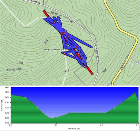
For example, the topo to the left is 2.7 GPS miles of turtle M3's travel in 2021. The red line is the location of the profile through M3's travel route.
Actual travel distance is often much greater than GPS distance.
DropTags are 1x2" self adhesive paper labels with a low strength adhesive that easily detaches with heat, moisture and friction. The turtle ID and location as well as the tracking year (i.e. M64-72 '21) are written on the tag with permanant ink, preferably firmly with a ball-point pen, and the tag is folded around the transmitter antenna, or alternately, pressed onto the turtle's carapace
As the turtle travels, especially through brush, the tag detaches, and if recovered later, the tag's location is recorded on a GPS as a turtle location (plus a "T" i.e. M64-72T). Dropped tags will survive several years on the ground, and the info can be added to the appropiate year's GPS/GIS records.
DropTags give less detailed travel information than thread-trailing, but require much less interaction from the user, and are much cheaper than a GPS logger. Turtle behavior is not modified by the use of DropTags. The tags are bio-degradable, non-toxic, and not harmful to wildlife.
Plastron tape and plastron teperature data logger